Geographic distribution of pressure. Centers of action of the atmosphere
1. Let us now consider maps of long-term average sea level pressure in January and July. Zonal features in pressure distribution can be easily seen on these maps. However, the influence of the uneven distribution of land and sea leads to the fact that in each zone the pressure field breaks up into separate cells, into areas of high and low pressure with closed isobars. These areas are called centers of atmospheric action. Some centers of action can be found on climatological maps of all months of the year; these centers are called permanent. Others are found on maps of only winter or only summer months; they are called seasonal centers of action.
2. January. Map XXIX clearly shows the equatorial depression with pressure below 1015 hPa. Within this depression there are three distinct areas of low pressure with closed isobars: over South America, South Africa and Australia and Indonesia. The pressure in the centers of all areas is below 1010 hPa. The areas with the lowest pressure in the equatorial depression are located in January not at the equator itself, but rather far from it: approximately 15° south. sh., over the warmed (summer here!) continents of the southern hemisphere.
On both sides of the equatorial depression, subtropical high pressure zones are found, which consist of several anticyclones with closed isobars. Such anticyclones are especially well pronounced over all three oceans of the southern hemisphere (with centers at 30-35° S and with pressure in the center above 1020 hPa); over continents that are warmer than the oceans, they are replaced by low pressure. In the northern hemisphere, subtropical anticyclones are found over the Atlantic and Pacific oceans (closed isobars at 1020 hPa), where their centers are also located at 30-35° latitude. The anticyclone over the North Atlantic Ocean is called the Azores, over the North Pacific Ocean - the Honolulu or Hawaiian.
Over Asia in subtropical and tropical latitudes the pressure is also increased. However, there is no independent subtropical anticyclone here: South Asia is occupied by the southern part of the huge Asian winter anticyclone centered in Mongolia.
In the temperate and subpolar latitudes of the southern hemisphere, south of the subtropical anticyclones, there is an almost continuous zone of low pressure, in which, however, several centers can be distinguished. At corresponding latitudes in the northern hemisphere, low pressure is found only over the oceans.
These are two oceanic depressions: the Icelandic in the north Atlantic Ocean and the Aleutian in the north Pacific Ocean with a pressure in the center below 1000 hPa. Over the continents of Asia and North America they are replaced by winter anticyclones: the Asian one, which has already been mentioned, and the Canadian one. In the Asian anticyclone, the pressure in the center is above 1035 hPa, in the Canadian anticyclone it is above 1020 hPa.
In polar latitudes, pressure is increased compared to subpolar latitudes. The high pressure area over Antarctica is especially well defined: the Antarctic anticyclone. In the northern hemisphere, the increase in pressure in the Arctic basin is insignificant. Only over icy Greenland is a closed isobar with a value of 1000 hPa visible, outlining an area of relatively high pressure.
3. July. Map XXX shows that the equatorial depression in July shifted to the north and the lowest pressure in it is no longer in the southern hemisphere, but in the northern hemisphere, where it is now summer. The low pressure centers over the warmed continents of the northern hemisphere have moved particularly far north: they are located around the 30th parallel in both Asia and North America. These parts of the equatorial depression, which extend over the heated continents even beyond the tropics, are called summer depressions: South Asian and Mexican.
High pressure zones in the subtropics are also visible. In the southern hemisphere, where it is winter in July, subtropical anticyclones capture not only the three oceans in the subtropics and tropics, but also the continents, which are now cold. But in the summer northern hemisphere, anticyclones remain only over two oceans (and, as can be seen from the maps, they move further north and even intensify). Over the continents of subtropical latitudes, the pressure, in contrast to January, as we have seen, is lower.
It remains low at higher latitudes. Thus, in the temperate and subpolar latitudes of the northern hemisphere, oceanic depressions (much less deep than in winter) and depressions over the continents form a continuous subpolar zone of low pressure around the entire hemisphere. To the north of it, the pressure increases slightly.
In the southern hemisphere in July, as in January, there is a low pressure zone in subpolar latitudes and an anticyclone over the Antarctic continent.
So, the zonality in the distribution of pressure is violated by the fact that the pressure over the continents increases in winter and decreases in summer. In winter, high pressure over the continents is found even in temperate and subpolar latitudes, where it is generally lower. In summer, over the continents, pressure decreases even in subtropical zones, where it is generally increased.
Map XXIX. Distribution of mean atmospheric pressure at sea level in January (hPa).
Card XXX. Distribution of mean atmospheric pressure at sea level in July (hPa).
Map XXXI. The average absolute height of the isobaric surface is 300 hPa in December-February. Heights in geopotential decameters.
Map XXXII. The average absolute height of the isobaric surface is 300 hPa in June-August. Heights in geopotential decameters.
4. The presence of centers of action on long-term average maps indicates that the same stable cyclone or anticyclone is located in certain places on the Earth all year round or throughout the entire season. In reality, cyclones and anticyclones in the atmosphere alternate quite quickly. It follows from climatological maps that in some places on the Earth cyclones prevail over anticyclones, and therefore centers of action with low pressure are outlined on the maps there (as, for example, in the north of the Atlantic Ocean - the Icelandic depression). In other places, anticyclones are observed much more often than cyclones, and therefore centers of action with high pressure are indicated on maps (like the Azores anticyclone in the subtropics of the Atlantic Ocean). In fact, at one time or another, for example, not one, but two subtropical anticyclones can be observed simultaneously over the North Atlantic Ocean, and even three over the North Pacific Ocean.
5. Previously, it was believed that in the polar regions anticyclones persist almost constantly, or, in any case, they prevail over cyclones so much that on long-term average maps there should be quite strong centers of action with high pressure - polar anticyclones. It is now known that in the Arctic the predominance of anticyclones over cyclones is very small, and therefore the Arctic anticyclone is outlined very poorly on long-term average maps. And over Antarctica, anticyclones do not have such exceptional constancy. But still, the Antarctic anticyclone is, on average, much better expressed than the Arctic anticyclone. The issue is particularly complicated by the high altitude of the continent of Antarctica itself above sea level at very low surface air temperatures above the icy surface. Adjusting pressure to sea level gives inflated results that are incomparable with sea level pressure values for the ocean and lowlands. In order to see how much higher the pressure over Antarctica is than over the surrounding ocean, it is necessary to draw maps not for sea level, but for a level of 3-4 km, close to the surface of the continent (for an isobaric surface of 700 hPa). Average monthly maps for the 700 hPa surface reveal the presence of an anticyclone over East Antarctica in all months of the year.
6. On long-term average maps of pressure topography for surfaces of 700, 500, 300 hPa, etc., it is clear that with height there are fewer and fewer closed isohypses outlining individual centers of action, and the pressure distribution becomes more and more zonal (maps XXXI, XXXII) . This is understandable, since with altitude the influence of the distribution of land and sea on temperature, and consequently on pressure, weakens. In the upper troposphere and lower stratosphere, absolute isohypses on average maps, and therefore isobars, circle the entire globe, of course not coinciding quite exactly with the latitudinal circles; at the same time, they bend somewhat towards low latitudes over warm continents. Only near the equator are individual anticyclones still found, even in the upper troposphere. So, the highest pressure will be near the equator, the lowest - over the polar region. True, in winter in the northern hemisphere the lowest pressure is shifted from the pole to the especially cold northeastern parts of Asia and North America.
In layers above 20-25 km in summer, the pressure distribution changes radically due to changes in the meridional temperature distribution. Above the pole, the pressure becomes increased, i.e., the circumpolar depression is replaced by an anticyclone.
Read more about meteorology and climate...
| Favorite Color Foam | Washing railway cars | Favorite Active Foam | Favorite Test, Ultra | Cleaning injectors | Boat washing |
Normal atmospheric pressure
Standard atmospheric pressure is 101325 Pa, 760 mmHg. Art. or 1.01325 bar. However, a person can easily tolerate a wide range of pressures. For example, in the city of Mexico City, the capital of Mexico with a population of almost 9 million people, the average atmospheric pressure is 570 mm Hg. Art.
Thus, the value of the standard pressure is determined accurately. And comfortable pressure has a significant range. This value is quite individual and completely depends on the conditions in which a particular person was born and lived. Thus, a sudden movement from an area with relatively high pressure to an area of lower pressure can affect the functioning of the circulatory system. However, with prolonged acclimatization, the negative impact disappears.
Meteor dependence what to do?
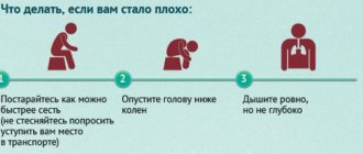
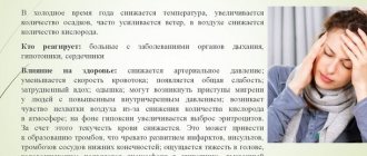
The movement of mercury by more than one division in 3 hours is a reason for stress in the strong body of a healthy person. Each of us feels such fluctuations in the form of headaches, drowsiness, and fatigue. More than a third of people suffer from weather dependence to varying degrees of severity. In the zone of high sensitivity are populations with diseases of the cardiovascular, nervous and respiratory systems, and elderly people. How to help yourself if a dangerous cyclone is approaching?
Read also: Fundus of the eye – what does it show?
15 ways to survive a weather cyclone
There's not a lot of new advice here. It is believed that together they alleviate suffering and teach the correct way of life in case of weather vulnerability:
- See your doctor regularly. Consult, discuss, ask for advice in case your health worsens. Always have prescribed medications on hand.
- Buy a barometer. It is more productive to track the weather by the movement of the mercury column, rather than by knee pain. This way you will be able to anticipate the approaching cyclone.
- Keep an eye on the weather forecast. Forewarned is forearmed.
- On the eve of a weather change, get enough sleep and go to bed earlier than usual.
- Adjust your sleep schedule. Provide yourself with a full 8 hours of sleep, getting up and falling asleep at the same time. This has a powerful restorative effect.
- Meal schedule is equally important. Maintain a balanced diet. Potassium, magnesium and calcium are essential minerals. Ban on overeating.
- Take vitamins in a course in spring and autumn.
- Fresh air, walks outside - light and regular exercise strengthens the heart.
- Don't overexert yourself. Putting off household chores is not as dangerous as weakening the body before a cyclone.
- Accumulate favorable emotions. A depressed emotional background fuels the disease, so smile more often.
- Clothes made from synthetic threads and fur are harmful due to static current.
- Keep folk remedies for relieving symptoms in a list in a visible place. It’s hard to remember a recipe for herbal tea or a compress when your temples are aching.
- Office workers in high-rise buildings suffer more often from weather changes. Take time off if possible, or better yet, change jobs.
- A long cyclone means discomfort for several days. Is it possible to go to a quiet region? Forward.
- Prevention at least a day before the cyclone prepares and strengthens the body. Do not give up!
Don't forget to take vitamins to improve your health
Atmospheric pressure is a phenomenon that is absolutely independent of humans. Moreover, our body obeys it. What the optimal pressure should be for a person is determined by the region of residence. People with chronic diseases are especially susceptible to weather dependence.