How does air press on the Earth?
Modern physics considers the normal average pressure to be when a column of atmosphere above 1 cm2 of area weighs 1.033 kg. The indicators were obtained at zero sea level at 0⁰С, at a latitude of 45⁰. This mass raises the mercury in the barometer tube upward by 760 mm. Sometimes the indicator is recorded in other physical units - Pascals.
Barometers are used to measure quantities:
- Mercury.
- Metal (aneroids).
The main part of a mercury chamber is a sealed glass tube, with the open end lowered into a container with mercury. The earth's air presses on the silvery liquid, which rises through a tube, next to which a millimeter scale is placed.
How many millimeters the bar has risen will be the value showing how much the atmosphere presses on an area of 1 cm2.
Mercury barometer
Aneroids are made according to a different principle. In essence, it is a metal box from which the air has been pumped out. The atmosphere (it is denser than the contents of the box) puts pressure on the walls, and they bend. Through a system of levers they are connected to an arrow that points to the current value.
The atmospheric pressure fluctuates around normal values and depends on the weather. The minimum (641.3 mmHg) was recorded inside Typhoon Nancy, which originated in the Pacific Ocean and hit Japan in 1961.
The mercury in the barometer rose to a record high (815.85 mm Hg) one winter in one of the cities of the Krasnoyarsk Territory in Russia. Before this, the Khubsubul aimag in Mongolia was considered the record holder.
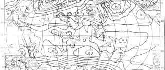
Zonal-regional distribution of atmospheric pressure at sea level
Near the earth's surface, the pressure field is differentiated into belts and regions.
In the equatorial belt, approximately 10° latitude wide, there is low (1000-1008 mb) atmospheric pressure throughout the year - an equatorial depression. The driving force behind its formation is the latent heat of vaporization. Of the total mass of water evaporated in the tropical oceans in a strip 70° wide (from 35° N to 35° S), 75% enters the equatorial belt. Thermal energy generates enormous kinetic energy, lifting the air to 18 km altitude.
The equatorial minimum is not the monotonous continuous band of low pressure that it seemed to be until recently. Against the background of general depression, areas of high pressure continuously appear and disappear, although, of course, their intensity is not comparable with anticyclones of temperate latitudes. Changes in pressure are associated with changes in weather, thunderstorms, and wind squalls. The reason for pressure fluctuations in the equatorial belt is hydrothermal, associated with the release of latent heat of vaporization when air masses meet, at least slightly different from one another.
The winds in this band are random and short-lived, calm prevails, and the entire band is called calm.
During ascending convection, steam condenses, and moisture, both brought to the equator from tropical zones and evaporated locally, falls in heavy equatorial rains, which are called zenithal (based on the position of the Sun at the zenith).
In tropical latitudes, between 35 and 20° of both hemispheres, tropical or subtropical pressure maxima with descending air currents are located on the oceans: Azores and Hawaiian in the northern hemisphere, South Atlantic, South Pacific and South Indian in the southern. The pressure in them is 1022-1026 mb. They last all year.
Proponents of the classical atmospheric circulation scheme explained the formation of tropical pressure maxima by the lowering of air that rose above the equator and was transported to tropical latitudes in the upper troposphere (this transfer was called anti-trade winds, the existence of which has not been confirmed). Now, based on the analysis of maps of synoptic and baric topography, as well as data from high-tropospheric devices, it has been found that tropical highs are formed by the regeneration of anticyclones that have moved from mid-latitudes to the critical parallels of 35°, at which the value of the Coriolis force changes sharply. At the equator it is zero; anticyclones do not penetrate here, which is one of the reasons for the existence of the equatorial depression.
On continents, in accordance with their thermal regime, the pressure system changes from winter to summer. In the summer part of the year of each hemisphere, the pressure on land is normal or reduced (in Australia, South Africa); in the tropics of South Asia, as we have already seen, there is a deep (994 mb) Iran-Tara minimum. In the January part of the year, winter in the northern hemisphere, the Azores and Hawaiian highs merge with the Siberian (1040 mb) and North American (1022 mb), forming a continuous band of high pressure over the subtropical temperate latitudes of the entire northern hemisphere.
In the winter of the southern hemisphere (July part of the year), a minor Australian High (1020 mb) forms over the Australian mainland.
Why is it not the same?
Atmospheric pressure changes and is affected by:
- altitude of a point above sea level;
- season;
- Times of Day;
- climate zone;
- temperature changes.
The higher, the lower
The higher the point above sea level, the more rarefied the air becomes, the lower the atmospheric pressure becomes. In the lower layers of the earth's air shell, the pressure decreases every 11 meters by 1 mm Hg.
For example, at an altitude of 20 km it is only 47 mmHg. Therefore, when rising to such a distance from the surface of the Earth, a person’s blood and interstitial fluids boil. If you are not in the pressurized cabin of an airplane or balloon, death will occur almost instantly.
It is known that different settlements on the planet have different levels of atmospheric pressure. This is logical, since they can be at different heights. For example, Chelyabinsk is built on a hill - 226 m from the zero level of the world ocean. Normal atmospheric pressure for him is 739 mm Hg.
The location of Kurgan in relation to the surface of the world's oceans is 72 m, and typical barometer readings that can be considered normal are 753 mm Hg. Art.
Temperature changes
What time of year it is - this also affects the indicator. It is higher in winter because winter air is colder and denser. In summer it is lower because the air is warmer and thinner.
The same temperature causes changes in the level of mercury during the day. Daily fluctuations occur within 4 - 5 mm, and seasonal fluctuations do not exceed 30 mm Hg. Art. All the same physical phenomena explain the fact that atmospheric pressure is constantly high in the Arctic and Antarctica, and low at the equator.
Cyclone as seen from space
Uneven heating of the air is a factor responsible for the formation of areas with low pressure around which cyclones form. A falling barometer reading may indicate the possibility of rain.
It is considered to be raining if the mercury is below 760 mm. And if you think about what atmospheric pressure is legitimately considered low and, conversely, high, then this figure will be the boundary criterion.
Weather-dependent people are very sensitive to pressure changes. Value below 750 mmHg. for many of them it is associated with unpleasant sensations.
Doctors explain this by the fact that when the barometer readings are low, the pressure of gases inside the body, in liquids and cavities, becomes higher than outside. This irritates the receptors in the organs and the person may feel aching in the joints.
In addition, oxygen starvation is felt, and cases of dizziness, drowsiness, and stunned state are not uncommon.
§12. Air pressure and precipitation at different latitudes
This I know
1. Why is atmospheric pressure low in the equator region near the Earth’s surface, and high in the upper layers of the troposphere?
In the region of the equator, the earth's surface receives a lot of heat. It heats the atmospheric air in the ground layers. Light warm air rises, so a low pressure area forms at the surface. Warm air with a lot of water vapor rises and cools. Rainfall occurs. The rising air enters the upper layers of the atmosphere already cooled, with increased pressure.
2. In what latitudes are belts of low atmospheric pressure located, and in which zones of high atmospheric pressure?
Low pressure belts form in equatorial and temperate latitudes. Increased pressure is observed at the poles and in tropical latitudes.
3. Name the main reason for the formation of atmospheric pressure belts.
The main reason for the formation of pressure belts is the uneven supply of heat to the earth's surface.
4. What is the distribution of cloudiness and precipitation on Earth related to?
Cloudiness and precipitation depend on the distribution of temperatures and pressure. In addition, precipitation is influenced by topography, winds, and ocean currents.
I can do this
5. Using the map in Figure 29, determine what the average annual precipitation is at the intersection of the Prime Meridian and the Tropic of the North. Compare with the average annual precipitation in your area.
The intersection of the Prime Meridian and the Tropic of the North is located in the Sahara Desert. Less than 100 mm of precipitation falls here per year. Most of Russia receives more precipitation than this indicator.
6. Comparing the map in Figure 29 and the physical map of the world, determine the areas where precipitation falls per year: less than 100 mm; from 500 to 1000 mm; 2000 mm or more. Explain how this relates to the distribution of atmospheric pressure belts.
Less than 100 mm of precipitation will fall in the tropics in northern Africa (Sahara Desert), on the western coasts in the tropical latitudes of Africa and South America, in the interior of Antarctica, in northern Greenland and the Canadian Arctic Archipelago, in most of the Arabian Peninsula, in the interior of Eurasia.
500-1000 mm: Atlantic coast of Eurasia, North America, South America; eastern coasts of Eurasia and Australia.
More than 2000 mm of precipitation per year falls in equatorial latitudes: in the Amazon, Ganges, on the coast of the Gulf of Guinea, on the islands of Indonesia, and the Philippines. In temperate latitudes, this amount of precipitation falls on the west coast of South America and on the coast of the Gulf of Alaska.