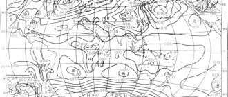
Climate zones and atmospheric pressure
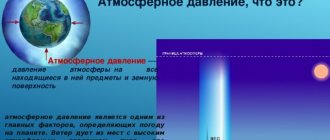
Atmospheric pressure depends on climatic zones of illumination and humidity, on the heating of the Earth by the rays of the Sun.
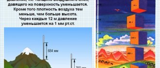
The reason for the appearance of atmospheric pressure belts is the difference in temperature of the air masses themselves, due to heating from the earth's surface. Due to the spherical shape of the Earth, different areas are heated unevenly by the Sun. This affects the formation of different weathering zones. What does the air temperature and low and high pressure zones have to do with it? How does cold air differ from warm air? What atmospheric pressure belts exist?
The density of cold air masses is greater than warm ones. And the higher the density, the heavier the air. The polar regions are cold, even in summer. Cold air is dense and heavy. Therefore, there is high atmospheric pressure there. In other words, the Arctic and Antarctic polar zones are the Earth's high pressure belts. It is always hot in equatorial regions. Warm air is light. Therefore, at the equator there is a low pressure belt of the Earth.
Pressure belts on earth
In tropical areas it is also hot, but at the same time a tropical zone of high atmospheric pressure is formed. What is the reason for this discrepancy in hot and dry tropics?
It's simple. At the equator, warm air rises to the upper limits of the troposphere and has a certain density, which gradually changes as the air cools. Spreading from the equator to the tropical zones, the same air masses, but with a different density and cold, descend to the Earth’s surface from the troposphere (see “Earth’s moisture belts”).
Between the two high pressure belts (between tropical and polar) lies a zone of low pressure. That is, the alternation is performed:
- Equator – low atmospheric pressure;
- Tropics – high atmospheric pressure;
- Temperate zones - n.d.;
- Polar – E.D.
- Dry climate - Arctic and Antarctic, Tropical - belts of high atmospheric pressure.
- Humid climate – Temperate and Equatorial – belts of low atmospheric pressure.
Tropical cyclones.
The homeland of tropical vortices is the ocean expanses in the equatorial region approximately between 10–15° northern and southern latitudes, their diameter is several hundred kilometers, and their height is from 5 to 15 km. Tropical cyclones can occur at any time of year in the tropical parts of all oceans except the southeastern Pacific and South Atlantic. Most often (in 87% of cases) tropical cyclones occur between latitudes 5° and 20°. At higher latitudes they occur in only 13% of cases. Cyclones have never been observed to occur north of 35° north latitude and south of 22° south latitude. Tropical cyclones that have reached significant intensity have their own name in each region. In the eastern part of the Pacific Ocean and in the Atlantic they are called hurricanes (from the Spanish word “huracan” or English “haricane”), in the countries of the Indian subcontinent – cyclones or storms, in the Far East – typhoons (from the Chinese word “tai”, which means strong wind). There are also less common local names: "willy-willy" - in Australia, "willy-wow" - in Oceania and "baguio" - in the Philippines. Pacific typhoons and Atlantic hurricanes are named according to established lists. There are four lists of names for typhoons, and one for hurricanes. Each typhoon or hurricane formed in a given calendar year, in addition to the name, is assigned a serial number with a two-digit year digit: for example, 0115, which means the fifteenth typhoon number in 2001.
Most often they form in the northern part of the tropical Pacific Ocean: here, on average, about 30 cyclones are tracked per year. Tropical cyclones reach temperate latitudes from late June to early October, and are most active in August-October. A distinctive feature of this group of cyclones is that they are thermally homogeneous (i.e., there are no temperature contrasts between different parts of the vortex), a colossal amount of energy is concentrated in them, and they bring with them stormy winds and heavy precipitation.
Tropical cyclones form where there is a high water surface temperature (above 26°), and the water-air temperature difference is more than 2°. This leads to increased evaporation, an increase in moisture reserves in the air, which, to a certain extent, determines the accumulation of thermal energy in the atmosphere and contributes to the vertical rise of air. The emerging powerful draft carries away more and more volumes of air, heated and moistened above the water surface. The rotation of the Earth gives the rising air a vortex motion, and the vortex becomes like a giant top, the energy of which is enormous. The central part of the funnel is called the “eye of the storm.” This is a phenomenal phenomenon that amazes with the peculiarities of its “behavior”. When the eye of the storm is well defined, precipitation suddenly stops at its boundary, the sky clears, and the wind weakens significantly, sometimes to calm. The shape of the eye of a storm can be very different, it is constantly changing. Sometimes there is even a double eye. The average diameter of the eye of a storm in well-developed cyclones is 10–25 km, and in destructive ones it is 60–70 km.
Tropical cyclones depending on their intensity:
1. Tropical disturbance – wind speeds are low (less than 17 m/s).
2. Tropical depression - wind speed reaches 17–20 m/s.
3. Tropical storm – wind speed up to 38 m/s.
4. Typhoon (hurricane) – wind speed exceeds 39 m/s.
There are four stages in the life cycle of a tropical cyclone:
1. Formation stage. It begins with the appearance of the first closed isobar (isobar is a line of equal pressure). The pressure in the center of the cyclone drops to 990 hPa. Only about 10% of tropical depressions develop further.
2. Young cyclone stage or development stage. The cyclone begins to quickly deepen, i.e. there is an intense drop in pressure. Hurricane-force winds form a ring with a radius of 40–50 km around the center.
3. Maturity stage. The drop in pressure in the center of the cyclone and the increase in wind speed gradually stop. The area of stormy winds and intense rainfall increases in size. The diameter of tropical cyclones in the developing and mature stages can range from 60–70 km to 1000 km.
4. Attenuation stage. The beginning of the filling of the pressure growth cyclone at its center). Attenuation occurs when a tropical cyclone moves to an area of lower water surface temperatures or when moving onto land. This is due to a decrease in the influx of energy (heat and moisture) from the ocean surface, and when reaching land also with an increase in friction with the underlying surface.
Moving towards temperate latitudes, tropical cyclones gradually lose their strength and die out.
Relationship between pressure belts and precipitation.
In climate zones with low atmospheric pressure, precipitation in large quantities prevails. And, on the contrary, in climatic zones with high air pressure, precipitation is observed to a lesser extent. Why is that? Because the process of condensation of water vapor into liquid droplets occurs when warm air masses rise into the troposphere. This physical phenomenon is typical for climatic zones with low atmospheric pressure - equatorial and temperate zones.
Relationship between atmospheric pressure belts and precipitation
Typhoons.
Typhoons are among the most powerful and destructive tropical cyclones; they occur over the ocean northeast of the Philippines. The average duration of a typhoon is 11 days, and the maximum is 18 days. The minimum pressure observed in such tropical cyclones varies widely: from 885 to 980 hPa. Maximum daily precipitation amounts reach 400 mm, and wind speeds reach 20–35 m/s. The main season for typhoons to occur in temperate latitudes is from July to September.
Name of vortices
To avoid confusion in the definition of cyclones by meteorologists, the area of low atmospheric pressure began to be called each by its own name. They reflected all his parameters, coordinates and speed of movement. It was proposed to name them with numbers and letters, the names of birds and animals. It was very popular to call cyclones by female names. It was convenient and efficient. However, in the late 70s, male names began to be used for such purposes. Such a system made it possible to avoid errors and confusion when exchanging information about an approaching storm.
Guess the riddle:
My first syllable is rightfully reputed to be the most agile of all - He is very quick on hand, foot and in action; My second syllable is the fruit of the circle of decisions - Her with the diameter of legal relations. My third syllable is an abstractly named man, No skin color, no surname, no rank. Putting them together, you form a creature, Which you would sooner die than kiss. Show answer>>
My first syllable is a preposition, The second is a signal of trouble, And sometimes all of me, You need it for water. Show answer>>
My symbol is simple - a flaming heart, But the door needs to be open. Show answer>>
Direction of the wind.
Wind direction refers to the direction from which it blows. You can indicate this direction by naming either the point on the horizon from where the wind is blowing, or the angle formed by the direction of the wind with the meridian of the place, i.e. its azimuth. In the first case, there are 8 main directions of the horizon: north, northeast, east, southeast, south, southwest, west, northwest. And 8 intermediate directions between them: north-northeast, east-northeast, east-southeast, south-southeast, south-southwest, west-southwest, west-northwest, north -northwest. Sixteen points of reference, indicating the direction from which the wind blows, have abbreviations:
| Table 3. | |||||||
| WITH | N | IN | E | YU | S | 3 | W |
| CCB | NNE | ESE | ESE | SSW | SSW | WNW | W.N.W. |
| C.B. | NE | SE | S.E. | SW | S.W. | NW | NW |
| BCB | ENE | SSE | SSE | WSW | WSW | CVD | NNW |
| N – north, E – east, S – south, W – west | |||||||
Edward Kononovich
Other meanings of this word:
Random riddle:
He produces sheets of Wide Latitude. They are held on strong stems by a hundred rough, tenacious fruits: If you don’t get around them, you’ll find them all on yourself.
Random joke:
You are the President of the United States. Terrorist Bin Laden blew up two skyscrapers and fled to Afghanistan. Iraq is trying to create a nuclear bomb. Korea has already created it. Select from the list what do you think needs to be done first? (a) Bomb Afghanistan. (b) Bomb Iraq. (c) Bomb Korea. (d) Think.
Did you know?
In one hour, the human body generates as much heat as is needed to boil 1 liter of ice water. And if the body, instead of skin, was covered with a heat-impervious case, then within an hour the body temperature would rise by about 1.5°, and after about forty hours it would reach the boiling point of water.
Scanwords, crosswords, sudoku, keywords online
Wind speed.
Estimation of wind speed in points, the so-called Beaufort scale, according to which the entire range of possible wind speeds is divided into 12 gradations. This scale relates the strength of the wind to its various effects, such as the degree of rough seas, the swaying of branches and trees, the spread of smoke from chimneys, etc. Each gradation on the Beaufort scale has a specific name. Thus, zero on the Beaufort scale corresponds to calm, i.e. complete absence of wind. Wind at force 4 is called moderate according to Beaufort and corresponds to a speed of 5–7 m/sec; 7 points – strong, with a speed of 12–15 m/sec; at 9 points – a storm, with a speed of 18–21 m/sec; finally, a wind of 12 points Beaufort is already a hurricane, with a speed of over 29 m/sec. At the earth's surface, we most often have to deal with winds whose speeds are on the order of 4–8 m/sec and rarely exceed 12–15 m/sec. But still, in storms and hurricanes of moderate latitudes, speeds can exceed 30 m/sec, and in some gusts reach 60 m/sec. In tropical hurricanes, wind speeds reach up to 65 m/sec, and individual gusts reach up to 100 m/sec. In small-scale vortices (tornadoes, blood clots), speeds of more than 100 m/sec are possible. In the so-called jet streams in the upper troposphere and lower stratosphere, the average wind speed over a long time and over a large area can reach 70–100 m/sec. Wind speed at the earth's surface is measured by anemometers of various designs. Instruments for measuring wind at ground stations are installed at a height of 10–15 m above the earth's surface.
| Table 2. WIND STRENGTH. | |||
| Beaufort scale for determining wind force | |||
| Points | Visual signs on land | Wind speed, km/h | Wind power terms |
| 0 | Calmly; smoke rises vertically | Less than 1.6 | Calm |
| 1 | The direction of the wind is noticeable by the deflection of the smoke, but not by the weather vane. | 1,6–4,8 | Quiet |
| 2 | The wind is felt by the skin of the face; leaves rustle; ordinary weather vanes turn | 6,4–11,2 | Easy |
| 3 | Leaves and small twigs are in constant motion; light flags flutter | 12,8–19,2 | Weak |
| 4 | The wind raises dust and pieces of paper; thin branches sway | 20,8–28,8 | Moderate |
| 5 | The leafy trees sway; ripples appear on land bodies of water | 30,4–38,4 | Fresh |
| 6 | Thick branches sway; you can hear the wind whistling in the electrical wires; difficult to hold umbrella | 40,0–49,6 | Strong |
| 7 | Tree trunks sway; it's hard to go against the wind | 51,2–60,8 | Strong |
| 8 | Tree branches break; It's almost impossible to go against the wind | 62,4–73,6 | Very strong |
| 9 | Minor damage; the wind tears smoke hoods and tiles from roofs | 75,2–86,4 | Storm |
| 10 | Rarely happens on land. Trees are uprooted. Significant damage to buildings | 88,0–100,8 | Heavy storm |
| 11 | It happens very rarely on land. Accompanied by destruction over a large area | 102,4–115,2 | Fierce Storm |
| 12 | Severe disruption (Scores 13–17 were added by the US Weather Bureau in 1955 and are used in the US and UK scales) | 116,8–131,2 | Hurricane |
| 13 | 132,8–147,2 | ||
| 14 | 148,8–164,8 | ||
| 15 | 166,4–182,4 | ||
| 16 | 184,0–200,0 | ||
| 17 | 201,6–217,6 | ||
Simplified diagram of tsunami formation.
Most often, tsunami waves are of seismic origin; during earthquakes, faults in the surface of the earth's crust are formed - cracks and, as a result, faults, shifts and thrusts, leading to the lowering or raising of significant areas of the bottom. At the same time, instantaneous changes in volume and pressure occur in the water column, causing the appearance of compression and rarefaction waves, which, upon reaching the ocean surface, cause its fluctuations and form a tsunami. The period of the generated waves ranges from 2 to 20 minutes, i.e. these are long waves. In the open sea these waves are not noticeable, but they carry enormous energy. The displacement speed of tsunami waves in deep water is 500–700 km/h. When moving, the tsunami energy is spent on overcoming the forces of viscosity and friction on the bottom. The intensity of a tsunami is related to the strength of the earthquake. In Russia, a 12-point scale is used to determine the intensity of an earthquake; in Japan, the unit of earthquake is magnitude, which is a value proportional to the logarithm of the maximum amplitude of horizontal soil (bottom) mixing at a distance of 100 km from the source of the earthquake. The strongest earthquakes have a magnitude of 8.5.
The main method of tsunami prediction is seismic, based on the existence of a difference between the speed of propagation of seismic waves in the earth's crust and the speed of propagation of tsunami waves in the ocean. Seismic waves reach the coast 50–80 times faster than tsunami waves. The seismic service registers an earthquake, determines its parameters, tsunamigenicity and transmits this information to the operational service of the Center for Marine Hydrometeorology.
| Table 1. MAIN CHARACTERISTICS OF WIND WAVES AND TSUNAMI WAVES | ||
| Options | Wind waves | Tsunami |
| Spread speed | up to 100 km/h | up to 1000 km/h |
| Wavelength | up to 0.5 km | up to 1000 km |
| Period | up to 20 seconds | up to 2.5 hours |
| Penetration depth | up to 300 m | to the very bottom |
| Wave height in the open sea | up to 30 m | up to 2 m |
| Wave height off the coast | up to 40 m | up to 70 m |
Over 99% of tsunami waves are caused by underwater earthquakes. During an earthquake, a vertical crack forms under water and part of the bottom sinks. The bottom suddenly stops supporting the column of water lying above it. The surface of the water begins to oscillate vertically, trying to return to its original level, the mean sea level, and generates a series of waves.